The forest
What grows on Hakuba Happo-One Snow Resort
Mostly deciduous: broadleaf woods and larch. They stand bare through the winter, so you can see a long way into them.
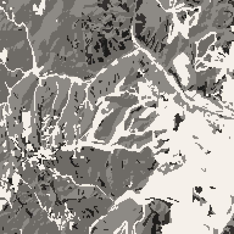
Read from the national vegetation survey. The survey records the cut pistes as open ground, so the ski area shows up on its own.
Where this mountain sits among the others on JapowDB
Its forest stands barer in winter than 36 of the 49 mountains on JapowDB.
01
Sight range, level by level
This is the mountain seen from the side. How far you can see into the trees changes with height.
| Height | What you can see through | Bare |
|---|---|---|
| 2,107–2,264 m | | 82% |
| 1,950–2,107 m | | 74% |
| 1,793–1,950 m | | 78% |
| 1,636–1,793 m | | 88% |
| 1,480–1,637 m | | 94% |
| 1,323–1,480 m | | 93% |
| 1,166–1,323 m | | 90% |
| 1,009–1,166 m | | 88% |
| 853–1,010 m | | 89% |
| 696–853 m | | 76% |
Each reading is a share of that band's own forest, not of the mountain, and a band holding too little forest to state one is left blank. The pale bar behind the section is how much ground sits at that height, so a swing over a sliver of mountain does not read as a headline. No treeline is drawn — the survey describes stands, not a line.
02
What stands beside each run
Each run is scored on the band 35 to 90 m either side of its centre line, which is the forest you look at from the piste. Runs are ordered by how much of that band you can see through in winter.
| Run | The band either side | See-through |
|---|---|---|
| Omusubi 352 m | 99% | |
| Kitaone Course 2 355 m | 79% | |
| Urakuro 798 m | 75% | |
| Kitaone Course 3 233 m | 71% | |
| Central Course 546 m | 70% | |
| Kitaone Course 1 770 m | 70% | |
| Kurobishi Rindō 5,068 m | 65% | |
| Sakka Course 1 578 m | 62% |
The other 18 runs
| Run | The band either side | See-through |
|---|---|---|
| Usagidaira Course 1 505 m | 61% | |
| Public Course 1,139 m | 61% | |
| Riesen Slalom Course 2,138 m | 60% | |
| Skyline Course 2 1,061 m | 60% | |
| Olympic Course I 942 m | 60% | |
| Olympic Course II 545 m | 55% | |
| Panorama Rindo 2,477 m | 54% | |
| Kurobishi 402 m | 50% | |
| Central Course 2 2,341 m | 49% | |
| Usagidaira Course 2 679 m | 48% | |
| Natures Happo Park 487 m | 47% | |
| Sakka Course 2 378 m | 39% | |
| Panorama Course 1,004 m | 36% | |
| Olympic DH women 703 m | 35% | |
| Riesen Grat Course 747 m | 31% | |
| Tenbo Course (summit) 518 m | 31% | |
| Skyline Course 1,293 m | 29% | |
| Shirababa Course 321 m | 22% |
Each figure is a share of the surveyed ground in a band 35–90 m either side of the run. The run itself and the rest of the mountain are outside it. The survey resolves about 18 m on the ground and the band is only a few cells wide, so the figure covers what the band is made of and cannot single out one tree, gap or line of sight. Runs the survey barely covers are left out. The survey has no treeline and no stem-density data.
03
What actually grows here
The survey sorts every polygon into one of its vegetation zones, then names the stand within it. A mountain usually falls into five or six zones, each holding many named stands.
| Vegetation zone | Share of classified ground | Share |
|---|---|---|
| Beech-zone regrowth ブナクラス域代償植生 | 36% | |
| Natural beech-zone forest ブナクラス域自然植生 | 25% | |
| Other その他 | 15% | |
| Plantation and farmland 植林地・耕作地植生 | 12% | |
| Natural subalpine conifer forest コケモモ-トウヒクラス域自然植生 | 9% | |
| Evergreen broadleaf-zone regrowth ヤブツバキクラス域代償植生 | 2% | |
| Alpine natural vegetation 高山帯自然植生域 | 1% | |
| Riverside, wetland, salt marsh and dune 河辺・湿原・塩沼地・砂丘植生 | 0% |
The named stands underneath
The survey’s own community names, largest first. These are proper names for stand types, and the survey publishes them only in Japanese.
- オオバクロモジ-ミズナラ群集 30%
- チシマザサ-ブナ群団 15%
- 緑の多い住宅地 8%
- 水田雑草群落 6%
- ススキ群団(V) 5%
- ササ-ダケカンバ群落 5%
The other 39 communities
- 自然裸地 4%
- ヒメヤシャブシ-タニウツギ群落 4%
- カラマツ植林 3%
- アカミノイヌツゲ-クロベ群集 3%
- ユキグニミツバツツジ-アカマツ群集 2%
- スギ・ヒノキ・サワラ植林 2%
- ヤナギ高木群落(IV) 2%
- ダケカンバ群集 2%
- 市街地 2%
- ナナカマド-ミネカエデ群落 1%
- アカマツ植林 1%
- 残存・植栽樹群をもった公園、墓地等 1%
- カライトソウ-オオヒゲガリヤス群集 1%
- オオシラビソ群集 1%
- コケモモ-ハイマツ群集 0%
- 畑雑草群落 0%
- 路傍・空地雑草群落 0%
- ササ群落(IV) 0%
- その他植林 0%
- ヤナギ低木群落(IV) 0%
- ウラジロヨウラク-ミヤマナラ群団 0%
- コメツガ群落 0%
- タテヤマアザミ-ホソバトリカブト群集 0%
- ヌマガヤオーダー 0%
- 造成地 0%
- オオヨモギ-オオイタドリ群団 0%
- クモマミミナグサ-コバノツメクサ群集 0%
- ツルヨシ群集 0%
- ニセアカシア群落 0%
- 放棄水田雑草群落 0%
- アカマツ群落(IV) 0%
- ヨシクラス 0%
- 工場地帯 0%
- 開放水域 0%
- イワイチョウ-ショウジョウスゲ群集 0%
- ササ群落(II) 0%
- タニウツギ-ノリウツギ群落 0%
- ツルコケモモ-ミズゴケクラス 0%
- 放棄畑雑草群落 0%
Every share is of the ground the survey classified on this mountain, which is more than the forest and more than the ski area. The zones are the survey’s own; the English is a gloss and the Japanese is the source term. Zones are ordered by area, and area has no bearing on how well a zone skis.
04
How natural this vegetation is
The survey grades every polygon on a ten-point scale of how little people have changed it. Level 1 is made ground with almost nothing growing on it; level 10 is natural grassland and alpine heath. The scale measures human interference only. Natural fir sits at 9 and is a wall you cannot see through; a larch plantation sits at 6, evenly spaced and good to ski.
| Level | Share of classified ground | Share |
|---|---|---|
| 10 | Natural grassland and alpine heath | 2% |
| 9 | Natural forest | 33% |
| 7 | Secondary forest | 32% |
| 6 | Plantation | 6% |
| 5 | Tall secondary grassland | 5% |
| 4 | Short secondary grassland | 0% |
| 3 | Orchard, tea and mulberry field | 1% |
| 2 | Farmland and green residential land | 14% |
| 1 | Built-up and made ground | 2% |
4% of the classified ground carries a code outside the ten levels. It is left out of the rows above.
Every share is of the ground the survey classified on this mountain. The scale records human interference only; a higher level does not mean better skiing. Levels this mountain does not have are left out.
National vegetation survey, 2024 edition, Biodiversity Center, Ministry of the Environment, Japan. Processed by JapowDB; the Ministry did not produce this version.
This mountain's polygons were walked in 2017. The edition is dated 2024; the fieldwork is older.
Each cell is about 18 m across, roughly the size of a small clearing.